
LOCATION:
Next the highway from Sant Lluís to Cala Binisafúller (Me-10), where it turns abruptly toward the south.
Sant Lluís.
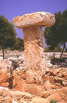
It appeared fallen during the excavation of the village and has been restored. It has reduced dimensions, showing the stone-capital the typical rabbet that facilitated its equilibrium on the stone-support, lifted on another stone. The precinct that surrounded it is in very bad state.
Stone-support:
Stone-capital:
It seems that the village was built in the Talayotic IV (450-123 B.C.), lasting its occupation until the Muslim time.
Next to it, we find a "talayot" in not very good conservation state, and, around this, a series of structures, with some small underground cavity that without a doubt constituted the base of the houses and the warehouses of the village.