LOCATION:

You arrive to it by the highway that leaves the one from Ciutadella to Cala Macarella and goes toward the Arenal de Son Saura.
Ciutadella.
It is without a doubt the most important western village, and one of the biggest in the island.
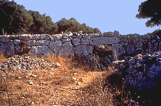
LWhat catch the attention are its perfectly preserved walls, in which it is simple to distinguish towers (five, as minimum), bastions, doors and huts (of rectangular plan and covered by approach of layers inside the structure of the defensive wall).
In the centre of the ensemble there is the enclosure of a "taula" with big dimensions destroyed on
purpose, since the furrow with which someone intents to break the
pilaster makes very plain. The remains of, at least, four talayots,
embedded to the wall, and of some houses, as well as a cave located
outside, complete the village, never studied profoundly, but in which
the tasks of cleaning, conservation and restoration have begun.
(More information in the web of Son Catlar: http://soncatlar.cjb.net ![]() )
)
It occupies some 3.75 hectares.
It seems that the talayots would date from the 1400-1200 B.C. (Talayotic I), while the walls would be, approximately, of the 10th century B.C. (Talayotic II). The towers of this walls present a certain Hellenistic taste, although they could also be Roman (in the enclosure of the "taula", a stone was found with the word LACESE, which seems to reinforce a possible continuation of the settlement during the Roman time).
In the small field located between the village and the highway to the "Arenal de Saura" there is an "hypogeum of elongated plan" of the Pretalayotic time.